


A Different Kind of Map: Try the 2018 Arlington County Comfort Level Map


Since its 2016 debut, Arlington County’s Comfort Level Map has become a highly popular tool with novice to expert riders. Get your free download today!
“There has got to be a better way!” How many times have you found yourself questioning this after following Google Map’s biking directions? (No, thanks, Google. I’ll pass on the steep hill followed by the shared road with four lanes of traffic.)
 No need to stress. BikeArlington’s Arlington County Comfort Level Map is here to help. Think of it as your friend who knows all the secretly awesome roads to bike on (and the ones to avoid).
In contrast to Google Maps or a conventional bike map, our Comfort Level Map offers a more holistic view that focuses on rider experience, rather than simply noting the type of bike infrastructure available. While the busy main road to your destination may have a painted bike lane, it might not be as comfortable or safe as the low-traffic neighborhood street around the corner. But, those routes can be tough to find, especially for new riders learning Arlington County’s twisty-turny street network.
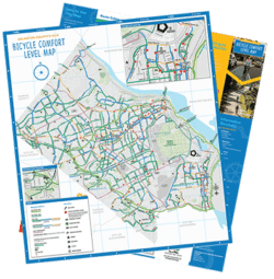
The Comfort Level Map makes safe, comfortable bike routes stand out by employing an intuitive color scheme.
Comfort by Colors:
- Green streets are the most comfortable, with blue roads right behind them. Together, these two colors present a network that will feel bikeable to most Arlingtonians.
- Orange streets will feel challenging to most riders, but may be okay for a few blocks to help connect to easier streets.
- Gray represents highways and high-stress local roads, which helps them fade into the background so riders do not consider them as part of their bike network.
- With outlines and dotted lines, bike lanes and multi-use trails are featured, but the best use of this map will focus on the comfort-rated color scheme.
With a quick glance at the prominent green and blue routes, we know bicyclists of any skill level will be able to chart an easy route to their destination and avoid stressful barriers.
Download your free digital copy by completing the form below.
Do you have a great commuting story? We want to hear from you. Email info@bikearlington.com.
Comments are closed here.
To prevent spam, comments will be approved before appearing on the post. If you have a comment or question, but do not want it to be published, please email BikeArlington.