


The Future of Trails: Arlington’s POPS Draft


Arlington is updating its Public Spaces Master Plan, and there's great news in it for trail-lovers!
LOOK AT THIS MAP:
Let’s just start with what caught my eye, this map, which was emblazoned on a banner at a recent open house, conducted as part of the POPS: A Plan for our Open Places and Spaces outreach process.
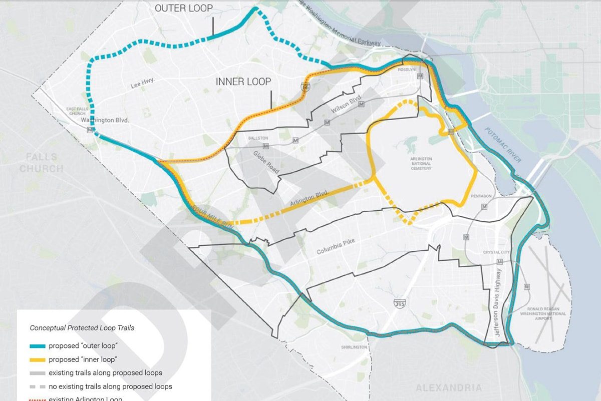
How neat would this be? We all love the Arlington Loop—our 16 mile loop of trails that circle the county. So how excellent would a central loop that takes you from the west end of the county all the way east and around Arlington National Cemetery on safe connections be? And how about all the additional Arlingtonians who would have easier trail access with an Outer Loop connection? So this map got me curious, where did these great ideas come from?
The conceptual loop trail map (above) is from the draft version of the Arlington Public Spaces Master Plan—which covers everything from natural resource stewardship to all the types of parks (and their varied uses) and more. Arlington County and the Parks and Recreation department are in the midst of a public outreach process (also called POPS), and a draft version of the plan is available online—and they’re welcoming all feedback until August 11.
There is a TON of thoughtful information in the plan, but I’m pulling out my three favorite things from the trails section for people walking and biking.
Three AWESOME highlights from the Strategic Direction on Trails
1. More trails—“2.1. Expand Arlington’s network of connected multi-use trails.”
This is the priority action for the section, and also where the map above comes from. In addition to the proposed inner and outer loops, this action addresses the need for better connections around current barriers, including many of the large highways and federal lands. It also highlights the need for addressing gaps in sidewalks near parks and trails.
What is interesting is that there is language that suggests that proposed routes might not necessarily be traditional trails, as the draft plan notes that “protected routes increase the safety and encourages more novice users to participate.” Particularly for some of the north loop, I wonder if “protected bike lanes” might also be considered. This could 100% be wishful thinking from an overactive brain.
2. Design-based solutions to deal with crowded trails—“2.2. Ensure trails function for a range of users.”
This section acknowledges how busy the trails are, and prioritizes both education and design solutions to address conflicts between different trail users—including call-outs for wider trails and mode-separated paths, design tools new-to-our area.
3. Better wayfinding—“2.4. Develop and implement a consistent signage and wayfinding system.”
Another common frustration for folks using the trails is the lack of clarity of where you are, where the trail goes and in some cases, confusion as to what trails you’re on. Supporting actions here include actually naming all of Arlington’s trail sections, developing a consistent trail wayfinding program and providing better information at trail heads.
But wait, there’s more!
The whole plan is worth a page through, including the Trails actions not covered here, as this will be Arlington County’s guiding direction of our parks and open spaces for years to come. Check it out, and be sure to share your thoughts with them by August 11.
Comments are closed here.
To prevent spam, comments will be approved before appearing on the post. If you have a comment or question, but do not want it to be published, please email BikeArlington.